About Arunachal Predesh
Arunachal Pradesh, often called the “Land of the Dawn-Lit Mountains,” is a unique and culturally rich state in northeast India. Created from the North-East Frontier Agency (NEFA), it gained statehood on 20 February 1987. Itanagar serves as the state capital and its largest town. The state shares borders with Assam and Nagaland to the south, Bhutan to the west, Myanmar to the east, and a contested border with China in the north. This border dispute has led China to claim Arunachal Pradesh as part of its Tibet Autonomous Region, referring to it as “South Tibet.”
Arunachal Pradesh: Exploring the Land of the Dawn
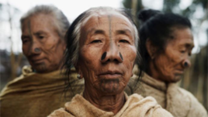
With a population of approximately 1.38 million (as per the 2011 Census) and an area of 83,743 square kilometers, Arunachal Pradesh is India’s least densely populated state, home to diverse ethnic groups. The major tribes include the Monpa, Nyishi, Adi, Apatani, and Mishmi, with sub-tribes adding to the state’s rich cultural tapestry. The Nyishi are the largest ethnic group, and the Mishmi tribe has three sub-groups: the Idu-Mishmi, Digaru-Mishmi, and Miju-Mishmi.
Etymology and Historical Names
Historically, eastern Arunachal Pradesh’s residents were referred to as Lhobha in Tibetan texts, and the region as Lhoyü, while the western areas were known as Monyul. The term “Arunachal Pradesh” itself derives from Sanskrit, meaning “Land of the Dawn-Lit Mountains.”
Ancient and Medieval History
The ancient history of Arunachal Pradesh is limited, with known records mainly concerning the western and northern areas, including interactions with Tibetan culture. The Monpa kingdom of Monyul, flourishing between 500 BCE and 600 CE, was under Tibetan influence. Tibetan chronicles mention that the region was once ruled by Tibetan princes, most notably Prince Tsangma and his descendants, who governed different areas within present-day Arunachal Pradesh.
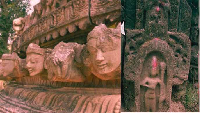
Medieval history highlights the influence of Tibetan Buddhism, marked by the construction of the Tawang Monastery under the guidance of the 5th Dalai Lama in the 17th century. It is the largest monastery in India and the second largest in the world. Fortresses known as Dzongs were built for administration and tax collection. Additionally, the region shows evidence of Chutia kingdom influences from Assam, visible in various historical sites like Bhismaknagar Fort, Ita Fort, and Malinithan Temple, which date back to the 13th and 14th centuries.
Modern Significance and Archaeological Sites
Arunachal Pradesh is notable for its archaeological treasures that showcase its historical richness. Sites like Bhismaknagar Fort, Dirang Dzong, and Tawang Monastery reflect the influence of both the Chutia dynasty and Tibetan Buddhism.
British India
Arunachal Pradesh, a state in northeast India, has a complex and historically rich background shaped by its strategic location, cultural diversity, and evolving political status. Originally part of the North-East Frontier Agency (NEFA), it gained statehood on February 20, 1987, with Itanagar as its capital. This mountainous state borders Bhutan, Myanmar, and China, and shares a significant border with Tibet that has been the subject of dispute, especially along the McMahon Line. China claims Arunachal Pradesh as part of its Tibet Autonomous Region, leading to longstanding territorial disagreements.
Historical Background and British India Involvement
Historically, regions of present-day Arunachal Pradesh were under the influence of local tribes, Tibetan governance, and kingdoms such as the Monpa, who have connections to Tibetan Buddhism. The British, interested in defining boundaries to secure their colonial interests, established the North-East Frontier Tracts in 1912–13. This area was later divided into Ballipara, Lakhimpur, and Sadiya tracts, marking the initial British administrative influence in the region.
In 1914, British representative Sir Henry McMahon proposed the McMahon Line, delineating the border between British India and Tibet. Although the Tibetan representatives agreed, China did not recognize this line, claiming Tibet lacked the authority to make territorial decisions. The McMahon Line remains a point of contention between India and China, contributing to regional tensions and military conflicts, most notably during the 1962 Sino-Indian War when China briefly occupied parts of Arunachal Pradesh.
Arunachal Pradesh and the Sino-Indian War
The border dispute intensified after India gained independence in 1947 and the establishment of the People’s Republic of China in 1949. The Chinese stance against the McMahon Line led to border conflicts, with China asserting control over Arunachal Pradesh in 1962, although it withdrew after declaring a ceasefire. This conflict severed barter trade with Tibet, but in recent years, India has indicated an interest in reopening such trade links.

Modern Era: Statehood and Territorial Claims
In 1972, the NEFA was renamed Arunachal Pradesh and later achieved statehood in 1987 under the Rajiv Gandhi administration. Although this marked the state’s integration into India, Chinese claims over the territory have persisted. In recent decades, China has occasionally reiterated its stance, and tensions have flared, such as during a 2017 visit to Tawang by the Dalai Lama, which China protested. The construction of villages along disputed areas, observed via satellite imagery, has further strained relations. India continues to reinforce its stance that Arunachal Pradesh is an integral part of its territory, an assertion it frequently reiterates in diplomatic discussions.
Insurgency and Security Concerns
Arunachal Pradesh also faces security issues related to insurgent groups like the National Socialist Council of Nagaland (NSCN), which seeks to incorporate parts of Arunachal into Nagaland. The Indian army maintains a presence in the region to prevent both insurgency and potential incursions by foreign forces. Access to Arunachal Pradesh is restricted, with the requirement of Inner Line Permits (ILPs) for non-residents to enter, enhancing security control over the region.
Arunachal Pradesh’s historical evolution and geopolitical significance underscore its cultural uniqueness and ongoing role in India’s border security and foreign relations with neighboring China and Southeast Asia.
Geography of Arunachal Pradesh
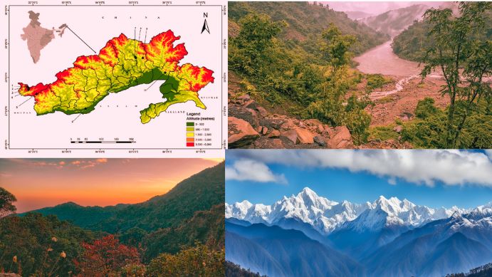
Arunachal Pradesh spans approximately 83,743 square kilometers and is situated between latitudes 26.28° N to 29.30° N and longitudes 91.20° E to 97.30° E. It is home to Kangto, the state’s highest peak at 7,060 meters, along with other notable peaks like Negi Kunsang and Gorinchem. These Himalayan Mountain ranges, often called the “Aruna Mountains,” reflect its historical name as “the land where the sun rises.” Dong and Vijayanagar, remote villages in the region, are among the first places in India to receive sunlight each day, attracting tourists.
Several major rivers traverse Arunachal Pradesh, including the Kameng, Subansiri, Siang (part of the Brahmaputra), Dibang, Lohit, and Noa Dihing. These rivers, originating from the Eastern Himalayas and Mishmi Hills, are fueled by glacial meltwater and seasonal rains. The state’s geography is segmented by mountain ranges, with the Pataki Range in the south and the Mishmi Hills marking the borders with Myanmar and China.
Climate
The climate of Arunachal Pradesh varies significantly due to elevation differences across the state. In the lower regions, a humid subtropical climate prevails, with warm summers and mild winters. Higher elevations experience a subtropical highland and alpine climate, with cool summers and harsh winters. The region receives substantial rainfall, ranging from 2,000 to 5,000 millimeters annually, with most precipitation occurring from May to October during the monsoon season.
Biodiversity Hotspot
Arunachal Pradesh boasts an extraordinary range of flora and fauna, making it one of India’s richest areas in terms of biodiversity. Approximately one-third of the state’s land area is designated as part of the Himalayan biodiversity hotspot, home to over 750 bird species and more than 200 mammal species. In 2013, about 31,273 square kilometers of Arunachal’s forests were classified as part of an intact forest landscape, connecting it to extensive forest areas in neighboring Bhutan, China, and Myanmar.
The state has three primary tiger reserves: Namdapha National Park, Mouling National Park, and Pakke Tiger Reserve, each providing sanctuary to a wide range of species. The unique ecosystem supports not only large mammals but also countless species of birds, insects, and butterflies, including several that are endemic to the region.
Flora of Arunachal Pradesh
The state has extensive forest cover, comprising about 77% of its total land area, with approximately 63,093 square kilometers of tree-covered land as of 2000. This vast vegetation includes over 5,000 plant species, with a substantial number of medicinal plants used by local communities, such as those in the Ziro Valley.
Forests in Arunachal Pradesh vary by altitude and climate. The Brahmaputra Valley semi-evergreen forests are predominant at lower altitudes near Assam, while the higher regions are covered by Eastern Himalayan broadleaf and subalpine conifer forests. Toward the Tibetan border, alpine shrublands and meadows emerge, giving way to rock and ice on the highest peaks. Diverse trees like rhododendron, oak, pine, maple, and fir contribute to the varied landscape, and the state houses two major national parks, Namdapha and Mouling, which are instrumental in preserving this rich plant life.

Fauna of Arunachal Pradesh
The state supports an impressive array of wildlife, including iconic species like the Bengal tiger, snow leopard, Asian elephant, and several species of deer, such as sambar, chital, and barking deer. Other mammals include the mithun (Bos frontalis), gaur, dhole, and sloth bear. Arunachal Pradesh is also home to unique species like the marbled cat and the Mishmi Hills hoolock gibbon, a new subspecies discovered in the region.
Arunachal has revealed new discoveries, such as three types of giant flying squirrels—the Mechuka, Mishmi Hills, and Mebo giant flying squirrels—highlighting the region’s significance in global biodiversity research. The abundance of rare and endemic species makes Arunachal Pradesh a vital region for conservation efforts and biodiversity protection, underscoring its ecological importance within India and across the Himalayan region.
Administrative Divisions
Arunachal Pradesh is divided into three primary divisions: Central, East, and West, each governed by a divisional commissioner. Within these divisions are 28 districts, each managed by a deputy commissioner. Among these districts, West Siang is the largest in area, while Tawang is the smallest. In terms of population, Papum Pare holds the largest number, while Dibang Valley is the least populated.
The state’s administrative setup includes prominent districts such as East Kameng, Papum Pare, Lower Subansiri, Tawang, and others, each with unique cultural and geographical significance. The headquarters of each division are Yazali in the West, Basar in the Central, and Namsai in the East.
Major Towns and Municipalities
Key urban centers in Arunachal Pradesh include the capital city, Itanagar, which is governed by the Itanagar Municipal Corporation. Other important municipal bodies include the Pasighat Municipal Council and various municipal committees in towns like Deomali, Aalo, Seppa, Tezu, Daporijo, and Ziro. Additionally, towns such as Roing, Tawang, and Khonsa contribute to the urban landscape, serving as local hubs of trade, education, and culture.
Here are some of the most famous cities in Arunachal Pradesh:
- Tawang: The birthplace of the 6th Dalai Lama, Tawang is known for its natural beauty and the Tawang Monastery.
- Ziro Valley: A popular destination known for its unique tribe and balmy climate.
- Bomdila: Home to famous temples and surrounded by the Himalayas.
- Mechuka: A scenic city known for its exotic tribes and majestic beauty.
- Dirang: A mesmerizing city known for its hot water spring, scenic views, and pleasant climate.
- Itanagar: A city with historical charm.
- Bhalukpong: A city with an adventurous spirit.
Demographics
Arunachal Pradesh’s population has grown steadily over the decades, from around 336,558 in 1961 to approximately 1,383,727 in 2011. The state’s cultural landscape is segmented into different tribal areas based on language, religion, and traditions. The Tibetic-speaking Monpa community resides in the western areas bordering Bhutan, while the Tani-speaking tribes occupy the central regions. In the east, the Mishmi tribes hold prominence, while the Tai, Singpho, and Tangsa groups, culturally linked with Myanmar, inhabit the southeastern areas. The Naga tribes, including Nocte and Wancho, reside in the south.
Each of these tribal regions includes closely related subtribes that share similar languages and customs. For instance, the Monpa tribes in the west have linguistic ties to Tibetan dialects, while the Tani area includes the Nyishi, Apatani, and Tagin communities with distinct yet interconnected cultural practices. The Adi tribes, such as the Padam, Pasi, and Minyong, reside in the eastern parts, with the Idu and Digaru Mishmi tribes forming another culturally distinct area.
Religion
Arunachal Pradesh is unique among Indian states, having a diverse religious composition with no single dominant faith. According to the 2011 Census, the religious distribution includes:
- Christianity: 30.26% of the population, representing the largest group.
- Hinduism: 29.04%, with many followers from the state’s various tribal communities.
- Donyi-Polo (Indigenous Faith): 26.20%, mainly among the Nyishi, Galo, and Adi communities who practice nature worship.
- Buddhism: 11.77%, primarily followed in the Tawang and West Kameng districts, where Tibetan Buddhism is prevalent, while Theravada Buddhism is practiced near the Myanmar border.
- Islam: 1.95%, mostly among a small minority in urban areas.
Christianity saw significant growth in Arunachal Pradesh, rising from 0.79% of the population in 1971 to over 30% in 2011. Indigenous faith practices continue to play a crucial role, with institutions like Nyedar Namlo, Rangfrah, and Kargu Gamgi preserving the traditional belief systems of various tribes.
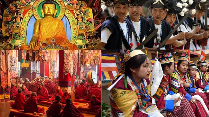
Buddhism holds a historical presence in Arunachal Pradesh, introduced from Tibet in the 8th century. Tibetan Buddhism influences are strong in areas close to the Tibetan border, while Theravada Buddhism, practiced by groups like the Tai Khamti, is present near Myanmar. Indigenous practices and cultural beliefs, especially the Donyi-Polo faith, retain significant importance, marking Arunachal Pradesh as a unique blend of religions and ethnic traditions.
Languages and Economy of Arunachal Pradesh
Arunachal Pradesh, located in the northeastern part of India, is a state rich in cultural and linguistic diversity. Known for its unique heritage, it is home to several tribal communities, each with its own language, customs, and traditions. This linguistic diversity also plays a key role in shaping the state’s identity. Alongside its cultural assets, the economy of Arunachal Pradesh is grounded in agriculture and forestry, with a growing focus on hydroelectric power. Here, we explore the linguistic landscape and economic backbone of this distinctive region.
Languages of Arunachal Pradesh
Arunachal Pradesh is one of the most linguistically diverse states in India, with a variety of indigenous languages spoken by different tribal groups. According to the 2011 Census, the most widely spoken language in the state is Nyishi, spoken by 20.74% of the population, followed by Adi at 17.35%, and Nepali at 6.89%. The other significant languages include Tagin, Bhotia, Wancho, Assamese, Bengali, Hindi, and Chakma.
The Tani languages, a branch of the Tibeto-Burman language family, dominate the linguistic profile in central Arunachal Pradesh. These languages are spoken by various indigenous groups, including the Nyishi, Apatani, Tagin, Galo, Bokar, Adi, and several others. Despite the diversity among Tani languages, there is a significant degree of mutual intelligibility among them, creating a linguistic continuum across the region. The Apatani and Milang languages stand out as they are relatively distinct from the other Tani languages, both in structure and lexicon.

In the eastern parts of the state, the Mishmi languages, such as Idu and Digaru, contribute to the region’s linguistic richness. These languages are considered highly endangered and have unique structures that set them apart from the Tani languages. The Singpho language, primarily spoken by the Singpho tribe, is closely related to the Kachin language spoken in Myanmar, further emphasizing the cultural ties between northeastern India and Southeast Asia. The Tai Khamti language is another unique linguistic component, representing the Tai family of languages and highlighting the cultural influences from northern Myanmar.
In the western part of the state, Bodic languages like Dakpa and Tshangla (known locally as Monpa and Memba) are spoken. These languages share strong affinities with languages in Tibet and Bhutan. English is the official language of Arunachal Pradesh, while Hindi serves as a lingua franca, especially among the non-tribal population and government employees, reflecting the influence of Hindi-speaking migrants. This diversity underscores the complex socio-cultural fabric of Arunachal Pradesh, where language plays a central role in identity.
Economy of Arunachal Pradesh
Arunachal Pradesh’s economy is primarily driven by agriculture, with jhum (shifting cultivation) practiced widely among various tribal communities. The state’s fertile land is well-suited for crops such as rice, maize, millet, wheat, pulses, sugarcane, ginger, and oilseeds. Additionally, the state’s favorable climate supports horticulture and fruit orchards, contributing to the local economy and providing employment for many residents. As Arunachal Pradesh moves toward modernization, there has been a gradual decline in the prominence of shifting cultivation, with more emphasis placed on other economic activities.
Forestry also plays a vital role in Arunachal Pradesh’s economy. Covering nearly 61,000 square kilometers of forested area, the state is rich in valuable forest products. Legal restrictions on sawmills and plywood production aim to protect this wealth, although some sawmills still operate within the state boundaries. The government’s policies support sustainable forest management practices to balance economic needs with environmental conservation.
One of the most promising sectors for Arunachal Pradesh’s future economy is hydroelectric power. The state holds a substantial portion of India’s untapped hydroelectric potential due to its extensive river networks. In 2008, the Arunachal Pradesh government signed multiple agreements for hydroelectric projects, which collectively aim to generate over 27,000 MW of electricity. The Upper Siang Hydroelectric Project, expected to produce between 10,000 and 12,000 MW, is one of the most ambitious undertakings in the state’s history. Launched in 2009, this project, along with others, has the potential to transform Arunachal Pradesh into a significant power supplier in the region, contributing not only to its economy but also to India’s overall energy requirements.

Overall, the economy of Arunachal Pradesh reflects a blend of traditional practices and modern development initiatives. Agriculture and forestry form the backbone of the state’s economic structure, while hydroelectric power generation offers promising avenues for growth. As Arunachal Pradesh continues to evolve, efforts to harness its natural resources sustainably while preserving its cultural heritage will play a crucial role in shaping its future.
Transport and Education in Arunachal Pradesh
Arunachal Pradesh, situated in India’s northeastern region, is not only known for its scenic beauty and diverse culture but also for the strides it is making in connectivity and education. Though geographically challenging, the state has witnessed substantial improvements in transportation, both through new infrastructure projects and increased accessibility. Additionally, the state government, alongside various NGOs, is working to enhance educational opportunities, leading to significant progress in literacy and higher education. Here’s an overview of the transport and education sectors in Arunachal Pradesh.
Transport in Arunachal Pradesh
Air Connectivity
Arunachal Pradesh’s remote location and mountainous terrain have historically posed challenges to air connectivity. Currently, the primary air project is the construction of Itanagar Airport, a Greenfield project at Holongi, near the capital Itanagar. Expected to cost ₹6.5 billion, this airport aims to improve access to the state’s capital significantly. Alliance Air operates the only regular flights into Arunachal Pradesh, with routes from Kolkata to Pasighat Airport via Guwahati. Initiated in May 2018 under the Regional Connectivity Scheme (UDAN), this route has improved connectivity to the state. Small state-owned airports, including Daporijo, Ziro, Along, and Tezu, are not operational but may be developed in the future, potentially furthering the state’s connectivity.
Road Connectivity
Road networks are vital for Arunachal Pradesh’s connectivity, with the Trans-Arunachal Highway (NH 13) serving as the state’s primary road. Spanning 1,293 km, this highway starts from Tawang, crosses the state’s breadth, and extends into Assam, concluding at Wakro. Initially announced in 2008, this highway was completed and became operational in 2018, providing a critical transportation link for residents and goods across the state.
NH-15, running through Assam, lines the southern border of Arunachal Pradesh and is complemented by the Bogibeel Bridge, an earthquake-resistant road-and-rail bridge over the Brahmaputra River. Opened in December 2018, this bridge enhances access to central Arunachal Pradesh, shortening travel times and boosting commerce with Assam. Additionally, NH-415 connects Itanagar, while state-owned Arunachal Pradesh State Transport Services (APSTS) offers bus services linking Itanagar to various districts and neighboring states, including Assam, Meghalaya, and Nagaland.
Looking ahead, the government has proposed two new highways for further connectivity: an Industrial Corridor Highway in the lower foothills and a Frontier Highway along the McMahon Line near the India-China border. These proposed routes could enhance transportation infrastructure for residents and promote economic growth.
Rail Connectivity
Arunachal Pradesh’s first railway line was introduced in 2013, linking Harmuti in Assam to Naharlagun in Arunachal Pradesh. The 33-kilometer broad-gauge railway line connects Naharlagun, close to Itanagar, to major Indian railway routes. In April 2014, Itanagar was officially added to India’s railway map, making long-distance rail travel possible for the state’s residents. A landmark moment for the state occurred in 2015 when the first train from New Delhi to Naharlagun was inaugurated. Future plans include extending railway lines further into the state, potentially reaching Tawang near the Chinese border, thus enhancing connectivity and accessibility for both civilians and goods.
Education in Arunachal Pradesh
Overview of Educational Development
Arunachal Pradesh has seen a progressive expansion of its education system, with both state initiatives and contributions from NGOs like the Vivekananda Kendra, which have collectively improved literacy rates. Major universities include Rajiv Gandhi University (formerly Arunachal University), Indira Gandhi Technological and Medical Sciences University, and Himalayan University. These institutions offer diverse programs, from undergraduate degrees to teacher training and health sciences, catering to both government and private management.

The state’s first college, Jawaharlal Nehru College in Pasighat, was established in 1964. Since then, the establishment of institutions like the North East Frontier Technical University (NEFTU) in Aalo and the National Institute of Technology (NIT) in Yupia in 2010 has bolstered technical and professional education. NERIST (North Eastern Regional Institute of Science and Technology), a deemed university, plays a central role in providing technical and managerial education, with entrance exams conducted annually to qualify students for further studies.
Accredited Institutions and Specialized Education
Several colleges in Arunachal Pradesh have been accredited by the National Assessment and Accreditation Council (NAAC). Noteworthy institutions include Jawaharlal Nehru College in Pasighat, St. Claret College in Ziro, and Indira Gandhi Government College in Tezu. These colleges have achieved various accreditation grades, reflecting their commitment to educational quality. Additionally, Rajiv Gandhi University, NIT Arunachal Pradesh, and other government colleges across districts also contribute to the state’s academic landscape.
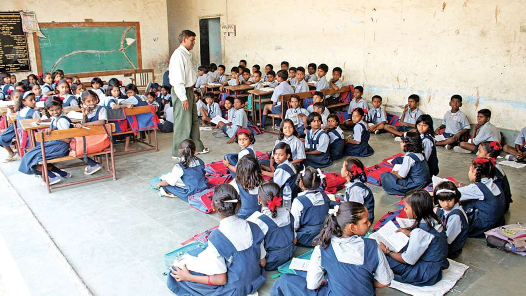
Arunachal Pradesh is home to unique educational institutions, including the Pali Vidyapith, managed by Buddhists. This institution educates students in Pali and Khamti scripts, offering instruction in traditional Buddhist teachings and subjects aligned with modern education. Libraries containing Buddhist scriptures, particularly in Lohit district, enrich the cultural and spiritual education available to students.
Technical, Legal, and Vocational Education
Arunachal Pradesh offers technical education through institutions such as the Rajiv Gandhi Government Polytechnic in Itanagar, established in 2002, and Tomi Polytechnic College in Basar, established in 2006. These polytechnic institutes provide diploma courses in various fields, equipping students with skills relevant to the local economy. Legal education is offered through the Arunachal Law Academy in Itanagar and the government-owned Jarbom Gamlin Government Law College. The College of Horticulture and Forestry, affiliated with the Central Agricultural University in Imphal, focuses on agricultural and forestry education, aligning with the state’s natural resources and agricultural needs.
In summary, Arunachal Pradesh is making strides in both transportation and education. Improved air, road, and rail connectivity have made travel and trade easier, fostering economic growth. On the education front, the establishment of colleges and specialized institutions is enhancing literacy rates and skill levels across the state. These developments are creating pathways for the residents of Arunachal Pradesh to access quality education and improved livelihood opportunities, setting a strong foundation for the state’s future.
Politics in Arunachal Pradesh
Arunachal Pradesh has seen its share of political turbulence, particularly in 2016, when a major political crisis led to President’s Rule being imposed in the state. Below is a summary of key events and important political developments in Arunachal Pradesh.
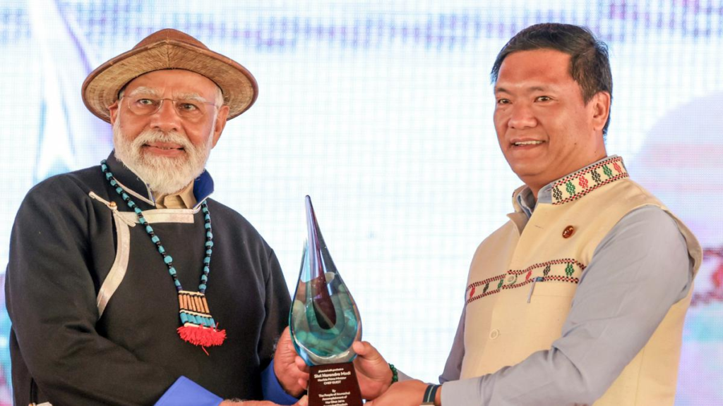
Political Crisis (2016)
- Nabam Tuki’s Leadership: The political crisis began with Nabam Tuki, who was the Chief Minister of Arunachal Pradesh from 1 November 2011 until January 2016. Tuki was replaced by Jarbom Gamlin as the Chief Minister, leading to a power struggle.
- President’s Rule (2016): In January 2016, political instability led to the imposition of President’s Rule, bringing an end to Tuki’s tenure. In February 2016, Kalikho Pul became the Chief Minister after 14 disqualified MLAs were reinstated by the Supreme Court.
- Supreme Court Ruling (July 2016): On 13 July 2016, the Supreme Court quashed the Arunachal Pradesh Governor J.P. Rajkhowa’s decision to advance the Assembly session from 14 January 2016 to 16 December 2015, which led to the reimposition of President’s Rule. This decision resulted in the reinstatement of Nabam Tuki as Chief Minister.
- Resignation of Nabam Tuki (July 2016): Despite being reinstated, Nabam Tuki resigned on 16 July 2016, just hours before a floor test was scheduled. He was succeeded by Pema Khandu from the Indian National Congress (INC), who later shifted to the People’s Party of Arunachal (PPA) in September 2016 with a majority of MLAs.
- Switch to BJP (December 2016): In December 2016, Pema Khandu and the majority of MLAs joined the Bharatiya Janata Party (BJP), a significant political shift, making Arunachal Pradesh the second northeastern state to experience such a change.
China’s Claims and Border Tensions
Arunachal Pradesh has been at the center of territorial disputes between India and China. Over the years, China has repeatedly made claims over Arunachal Pradesh, calling it “Southern Tibet” and asserting ownership of the region. Key events include:
- Name Alterations (2017, 2021, 2023): In these years, China released lists of name alterations for multiple locations in Arunachal Pradesh, including mountains, rivers, and residential areas. These alterations were made in both Chinese and Tibetan languages as part of China’s territorial claim.
- China’s Map (2023): On 28 August 2023, China released a new “standard map”, which depicted Arunachal Pradesh as part of China’s territory. The Indian government rejected these claims, reiterating its sovereignty over the region.
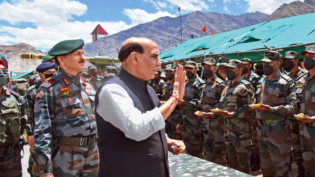
- Military Presence: With increasing border tensions, both India and China have ramped up their military presence along the India-China border, making the region a flashpoint for future confrontations.
State Symbols of Arunachal Pradesh
Arunachal Pradesh has its own set of state symbols, reflecting its rich cultural heritage and natural beauty:
- Emblem: The Emblem of Arunachal Pradesh.
- Animal: Mithun (Bos frontalis) – A symbol of the state’s indigenous culture.
- Bird: Hornbill (Buceros bicornis) – A species native to the state, symbolizing the state’s rich biodiversity.
- Flower: Foxtail orchid (Rhynchostylis retusa) – A unique flower found in the state.
- Tree: Hollong (Dipterocarpus retusus) – The state tree, revered for its cultural significance and prominence in the state’s forests.
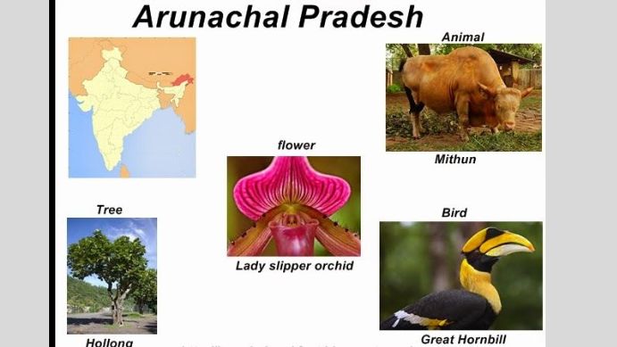
These symbols reflect the unique identity of Arunachal Pradesh, deeply rooted in its indigenous culture, flora, and fauna.

