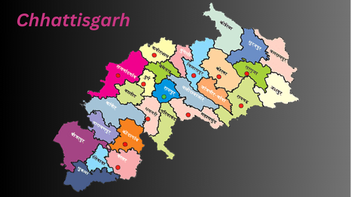
History of Chhattisgarh
Chhattisgarh, a landlocked state in Central India, is the ninth largest in area and seventeenth most populous, with a population of around 30 million. Established as a separate state from Madhya Pradesh on November 1, 2000, Chhattisgarh has Raipur as its capital and borders seven states, including Uttar Pradesh, Madhya Pradesh, and Odisha.
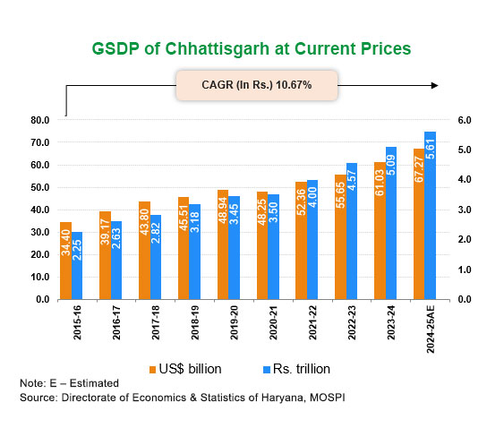
The state has significant natural resources, including India’s third-largest coal reserves, which contribute to its economy alongside electricity and steel production. With 40% of its area covered in forests, Chhattisgarh also boasts the third-largest forest cover in India. Its economy is rapidly developing, with a Gross State Domestic Product (GSDP) of ₹5.09 lakh crore (2023-24 est.).
Chhattisgarh Unveiling the Rich History
The origin of the name “Chhattisgarh” is debated. The most common theory suggests it comes from “chhattis” (thirty-six) and “Gahr” (fort), referring to 36 ancient forts in the region, though these forts have not been definitively identified. Historically known as Dakshina Kosala, Chhattisgarh has connections to the Chedi dynasty and the Sambalpur Kingdom of Odisha.
Ancient and Medieval History
In the post-Vedic period, the Chhattisgarh region, located southeast of the Daśārṇas, was known as Pulinda, dominated by the Pulinda tribe. Evidence of early civilizations includes the discovery of Mauryan and Nanda period coins in Surguja District, along with a significant collection of gold and silver coins from the Nanda-Mauryan ages found in the Akaltara and Thathari areas of Bilaspur.
Sitabenga Caves, located on Ramgarh Hill, are among the earliest examples of Indian theater architecture, dating back to the Mauryan period in the 3rd century BCE. The Jogimara caves contain Brahmi script inscriptions and are considered to have some of the oldest paintings in India, possibly as a love proclamation or as documentation of a cave theater built for artistic performances. This region, known in ancient texts as Dakshina Kosala, is also mentioned in the Ramayana and Mahabharata. One of India’s oldest Vishnu statues from the Shunga period has been excavated from Malhar, adding to the area’s historical significance.
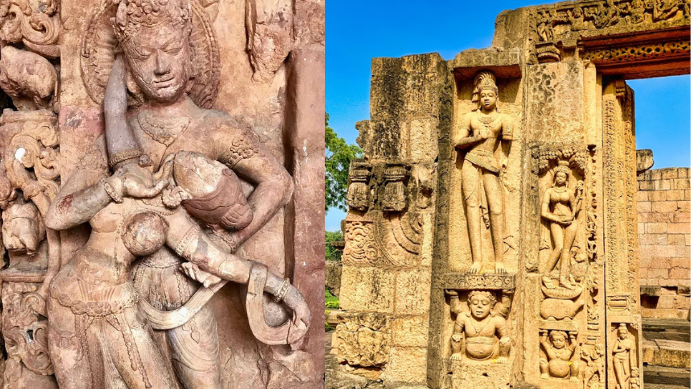
Between the 6th and 12th centuries, Chhattisgarh was ruled by several dynasties including the Sharabhpurias, Panduvanshis (of Mekala and Dakshina Kosala), Somavanshi, Kalachuri, and Nagavanshi. The Bastar region witnessed invasions by Rajendra Chola I and Kulothunga Chola I of the Chola dynasty in the 11th century. Later, much of Chhattisgarh was unified under the Haihaiyavanshi Kingdom, which controlled central Chhattisgarh, including the smaller Kanker kingdom. The Haihaiyavanshis ruled for about 700 years until the Marathas invaded in 1740, integrating Chhattisgarh into the Maratha Nagpur Kingdom by 1758.
Modern History
Under Maratha rule, Chhattisgarh was governed by the Bhonsles of Nagpur from 1741 to 1845, after which it came under British control. During British rule, Chhattisgarh became a part of the Central Provinces as the Chhattisgarh Division. This period marked Raipur’s rise over Ratanpur as the administrative center in 1845. In 1905, some territorial adjustments occurred, transferring Sambalpur to Odisha and Surguja estates to Chhattisgarh.

Post-independence, Chhattisgarh merged into Madhya Pradesh on 1 November 1956 as part of the States Reorganisation Act. Before this, some regions of present-day Chhattisgarh were princely states under British rule but were later integrated into Madhya Pradesh.
Movement for Statehood
The demand for a separate Chhattisgarh state began as early as the 1920s, with calls for recognition but limited organizational momentum. In 1924, the Raipur Congress unit first raised this demand, which was discussed at the Indian Congress in Tripuri. The State Reorganization Commission of 1954 rejected the proposal, though the demand re-emerged in various political forums.
By the 1990s, the movement gained traction, leading to the formation of the Chhattisgarh Rajya Nirman Manch, a statewide political forum headed by Chandulal Chandrakar. Supported by major political parties, such as the Indian National Congress and Bharatiya Janata Party, this forum organized successful region-wide strikes and rallies. The National Democratic Alliance (NDA) government eventually approved the Separate Chhattisgarh Bill, which passed through the Lok Sabha and Rajya Sabha.
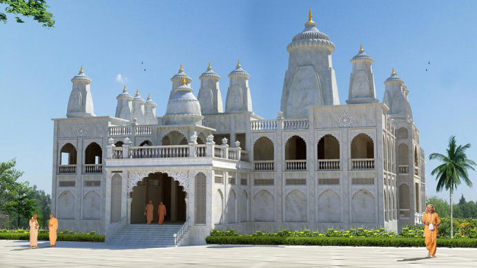
On 25 August 2000, President K. R. Narayanan approved the Madhya Pradesh Reorganizations Act, designating 1 November 2000 as the official date for Chhattisgarh’s separation from Madhya Pradesh, thereby marking the birth of the new state.
Geography of Chhattisgarh
Chhattisgarh’s landscape is a blend of highlands, fertile plains, dense forests, and rivers that shape its diverse ecosystems. The state’s northern and southern regions feature rugged hills and dense greenery, while the central area is an agricultural heartland, with expansive plains that are perfect for rice cultivation. Gaurlata, the state’s highest peak, lies near Samri in the Balrampur-Ramanujganj district.
The state’s forests, which cover nearly 44% of the land, are part of the Eastern Highlands Forests. This green belt is significant for both biodiversity and local communities. To the north, the Indo-Gangetic plain forms a unique ecological boundary, drained by the Rihand River. The Satpura Range and Chota Nagpur Plateau run along the eastern part of the state, providing natural barriers and marking the division between the Mahanadi River basin and the Indo-Gangetic plains.

In the central plains, the Mahanadi River flows through one of the most fertile regions in Chhattisgarh, supported by its major tributary, the Shivnath River. The Maikal Hills in the west separate the Mahanadi basin from the Narmada basin. The state’s southern region is part of the Deccan Plateau, with rivers like the Godavari and Indravati draining its rich soils. Chhattisgarh’s major rivers, including Hasdeo, Indravati, and Jonk, support agriculture, industry, and diverse ecosystems.
Forests and Wildlife
Chhattisgarh’s forests, ranking third largest in India, are home to iconic wildlife and are essential for biodiversity conservation. The state animal, the wild Asian buffalo or van bhainsa, roams its forests, while the pahari myna serves as the state bird. The Sal tree (Shorea robusta), especially prominent in the Bastar division, is the state tree, forming dense forest canopies that shelter diverse flora and fauna.
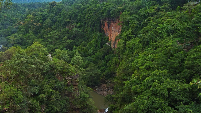
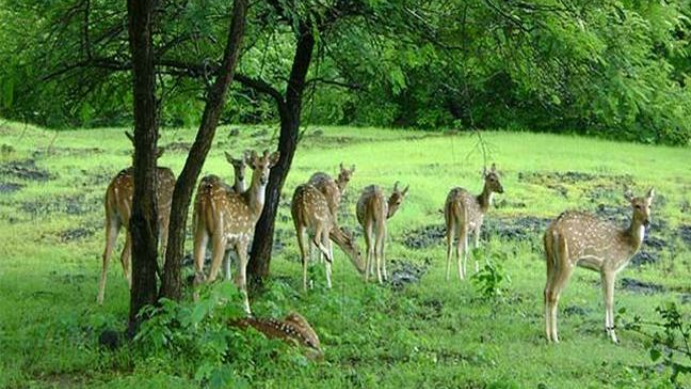
The Achanakmar-Amarkantak Biosphere Reserve, spanning over 383,000 hectares, is recognized by UNESCO for its ecological significance. This biosphere reserve and other national parks and reserves in Chhattisgarh protect endangered species, contribute to environmental balance, and provide habitats for tigers, leopards, and numerous bird species.
Climate
Chhattisgarh has a tropical climate with clear seasonal variations. Summers, from March to June, are hot and humid, with temperatures often rising to 49°C (120°F). The state’s tropical positioning near the Tropic of Cancer intensifies summer conditions, making monsoon rains from June to October vital. The annual average rainfall is approximately 1,292 mm (50.9 in), bringing much-needed cooling and nourishment to agriculture. Winters, from November to January, offer a pleasant climate with cool temperatures, particularly in areas like Ambikapur, Mainpat, Pendra Road, Samri, and Jashpur, known for their mild winters.
Transportation
Road Network
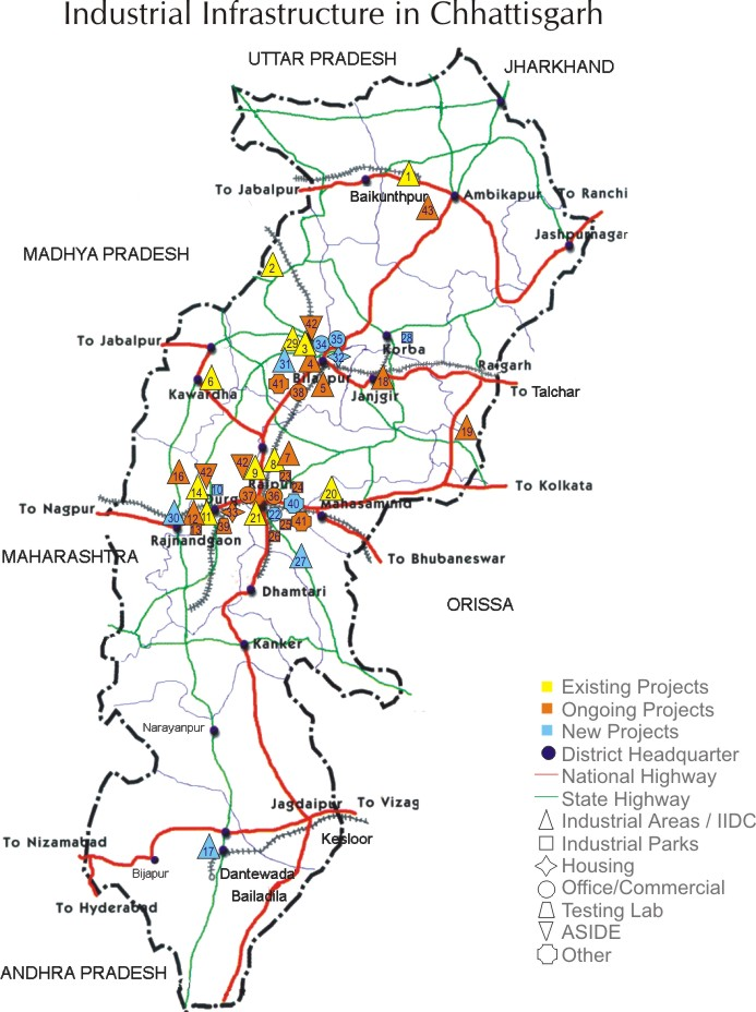
Chhattisgarh’s road system connects cities, towns, and rural regions, with national highways spanning around 3,078 km. However, several highways remain under construction, with ongoing upgrades to meet four-lane and multi-lane standards. Key highways such as NH 53, NH 16, NH 43, and newly planned routes like NH 130A-D and NH 930 aim to enhance connectivity.
Additionally, an 8,031 km network of state highways and district roads supports local transportation, linking urban centers to remote areas and improving access to education, healthcare, and markets. This extensive network is essential to the economic development of the state, although infrastructure improvements are still underway to bring it up to national standards.
Rail Network in Chhattisgarh
Chhattisgarh’s rail system is a significant component of India’s Southeast Central Railway Zone, with Bilaspur as the zone’s headquarters. The state’s rail network extends over 1,108 km, with approximately 85% of the tracks electrified. The Maroda–Bhanupratappur line is one of the few remaining non-electrified routes, spanning 120 km from the Durg–Bhanupratappur branch. The main railway hubs—Bilaspur Junction, Durg Junction, and Raipur Junction—serve as vital points of connectivity, with many long-distance trains originating from these stations. These junctions rank among India’s top 50 busiest stations, facilitating extensive travel options across the country.

Chhattisgarh plays a key role in India’s rail freight, generating the highest freight loading among Indian states. The state’s industries, especially in coal and iron ore, rely heavily on rail freight for efficient transport along the east-west corridor that connects Mumbai to Howrah. Despite its extensive freight services, there are limited passenger routes connecting the state’s northern and southern regions, indicating a need for improved passenger-focused infrastructure.
Key Railway Stations in Chhattisgarh:
- Bilaspur Junction
- Durg Junction
- Raipur Junction
- Ambikapur
- Raigarh
- Korba
- Champa Junction
- Mahasamund
- Rajnandgaon
- Dongargarh
- Gevra Road
- Pendra Road
- Bhatapara
Expanding rail projects in Chhattisgarh, such as the Dalli–Rajhara–Jagdalpur, Pendra Road–Gevra Road, and Raigarh–Mand Colliery to Bhupdeopur lines, aim to enhance connectivity, particularly for resource transportation. These additions are set to support both passenger and freight services, creating a more accessible network for all regions within the state.
Air Network in Chhattisgarh
Chhattisgarh’s air infrastructure is centered around Swami Vivekananda Airport in Raipur, which serves as the state’s primary air travel hub with direct connections to major cities across India. Supporting regional air travel are Bilaspur Airport, Jagdalpur Airport, and Ambikapur Airport, which offer scheduled services to boost local connectivity. These airports are crucial for promoting tourism, facilitating business travel, and linking remote regions to larger urban centers.

A notable policy shift in 2003, reducing the sales tax on aviation turbine fuel (ATF) from 25% to 4%, encouraged airlines to increase routes in the region, driving significant growth in passenger numbers. Between 2011 and 2012, air passenger flow in Chhattisgarh rose by 58%, a trend expected to continue with ongoing infrastructure improvements and increased flight frequencies.
Governance of Chhattisgarh
- Legislative Assembly: Composed of 90 members.
- Parliament Representation: Chhattisgarh has 11 members in the Lok Sabha and 5 members in the Rajya Sabha.
Administrative Divisions
Chhattisgarh is divided into several administrative divisions, each with numerous districts:
- Bastar Division: Includes districts such as Bastar, Bijapur, Dakshin Bastar Dantewada, Kondagaon, Narayanpur, Sukma, and Uttar Bastar Kanker.
- Durg Division: Encompasses districts like Balod, Bemetara, Durg, Kabirdham, Khairagarh-Chhuikhadan-Gandai, Mohla Manpur, and Rajnandgaon.
- Raipur Division: Contains Baloda Bazar, Dhamtari, Gariaband, Mahasamund, and Raipur.
- Bilaspur Division: Comprises Bilaspur, Gaurela-Pendra-Marwahi, Janjgir-Champa, Korba, Mungeli, Raigarh, Sarangarh-Bilaigarh, and Shakti.
- Surguja Division: Includes Balrampur-Ramanujganj, Jashpur, Koriya, Manendragarh-Chirmiri-Bharatpur, Surajpur, and Surguja.
Districts of Chhattisgarh (With Major Cities)
| District | Headquarter | Largest City | Other Major Cities |
|---|---|---|---|
| Raipur | Raipur | Raipur | Arang, Tilda-Neora |
| Bilaspur | Bilaspur | Bilaspur | Kota, Bilha |
| Durg | Durg | Bhilai | Charoda, Kumhari, Patan |
| Korba | Korba | Korba | Katghora, Dipka, Pali |
| Raigarh | Raigarh | Raigarh | Kharsia, Gharghora |
| Rajnandgaon | Rajnandgaon | Rajnandgaon | Dongargarh, Dongargaon |
| Koriya | Baikunthpur | Baikunthpur | Ramgarh |
| Surguja | Ambikapur | Ambikapur | Sitapur |
| Balrampur-Ramanujganj | Balrampur | Balrampur | Ramanujganj |
| Jashpur | Jashpur Nagar | Jashpur Nagar | Kunkuri, Patthalgaon, Tapkara |
| Surajpur | Surajpur | Surajpur | Telgaon, Bishrampur |
| Janjgir–Champa | Janjgir | Janjgir-Naila, Champa | Akaltara, Shivrinarayan |
| Mungeli | Mungeli | Mungeli | Lormi, Takhatpur |
| Kabirdham | Kawardha | Kawardha | Pandariya, Pandatarai |
| Bemetara | Bemetara | Bemetara | Nawagarh, Saja |
| Balod | Balod | Balod | Dalli-Rajhara |
| Baloda Bazar-Bhatapara | Baloda Bazar, Bhatapara | Bhatapara | Simga, Palari, Lawan, Kasdol |
| Gariaband | Gariaband | Gariaband | Rajim, Deobhog |
| Mahasamund | Mahasamund | Mahasamund | Saraipali, Bagbahra |
| Dhamtari | Dhamtari | Dhamtari | Kurud |
| Bijapur | Bijapur | Bijapur | Sangampal, Kasiguda |
| Narayanpur | Narayanpur | Narayanpur | Kodenar, Orchha |
| Kanker | Kanker | Kanker | Bhanupratapur, Pakhanjore |
| Bastar | Jagdalpur | Jagdalpur | Bastar |
| Dantewada | Dantewada | Dantewada | Kirandul, Geedam |
| Kondagaon | Kondagaon | Kondagaon | Keshkal |
| Sukma | Sukma | Sukma | Tadmetla, Murtonda |
| Gaurela-Pendra-Marwahi | Gaurella | Pendra | Marwahi, Basti-Bagra, Rajmergarh, Pasan |
| Manendragarh-Chirmiri-Bharatpur | Manendragarh | Chirmiri | Khongapani, Jhagrakhand, New Ledri, Janakpur |
| Mohla Manpur | Mohla | Mohla | Chilamtol |
| Sakti | Sakti | Sakti | Sonthi |
| Sarangarh-Bilaigarh | Sarangarh | Sarangarh | Bilaigarh |
| Khairagarh-Chhuikhadan-Gandai | Khairagarh | Khairagarh | Chhuikhadan |
Major Cities in Chhattisgarh (Population Estimates from 2011 Census)
- Raipur (Raipur District) – Population: 1,010,087
- Bhilai-Durg (Durg District) – Population: 1,003,406
- Bilaspur (Bilaspur District) – Population: 717,030
- Korba (Korba District) – Population: 365,253
- Ambikapur (Surguja District) – Population: 214,575
- Rajnandgaon (Rajnandgaon District) – Population: 163,122
- Raigarh (Raigarh District) – Population: 150,019
- Jagdalpur (Bastar District) – Population: 125,463
- Chirmiri (Koriya District) – Population: 103,575
- Dhamtari (Dhamtari District) – Population: 101,677
- Mahasamund (Mahasamund District) – Population: 54,413
Economic Overview
- Nominal Gross State Domestic Product (GSDP): ₹5.09 lakh crore (US$61 billion) for 2023–24, ranking 17th largest in India.
- Growth Rate: 11.2% in 2023–24, attributed to agriculture and industrial production.
- GDP by Sector:
- Agriculture: 32%
- Industry: 32%
- Services: 36%
- Per Capita GDP: ₹152,348 (US$1,800).
Public Finances
- Government Debt: 23.8% of GSDP.
- Budget Deficit: ₹−17,461 crore (3.33% of GSDP).
- Revenue: ₹106,301 crore; Expenses: ₹121,495 crore.
Agriculture Sector
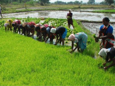
- Primary Occupation: 80% rural population relies on agriculture.
- Major Crops: Rice (main crop, covering 77% of cultivated area), maize, millets, pulses, oilseeds.
- Rice Bowl of Central India: Chhattisgarh is known for its extensive rice cultivation.
- Limited Irrigation: Only 20% of the area is irrigated, heavily dependent on rainfed agriculture, especially rice. Irrigation development remains a priority.
Industrial Sector
- Power Production:
- Surplus electric power production, providing electricity to other states.
- Key Plants: NTPC’s Korba and Sipat plants, Chhattisgarh State Electricity Board.
- Potential of 61,000 MW additional thermal power due to vast coal reserves.
- Steel Industry:
- Bhilai Steel Plant is a major contributor with over 100 steel rolling mills and 90 sponge iron plants in the state.
- Raipur, Bilaspur, Korba, and Raigarh serve as the state’s steel hubs.
- Aluminium Sector:
- Vedanta Resources (formerly Bharat Aluminium Company) operates a major plant in Korba with a capacity of 5.7 million tonnes annually.
Natural Resources
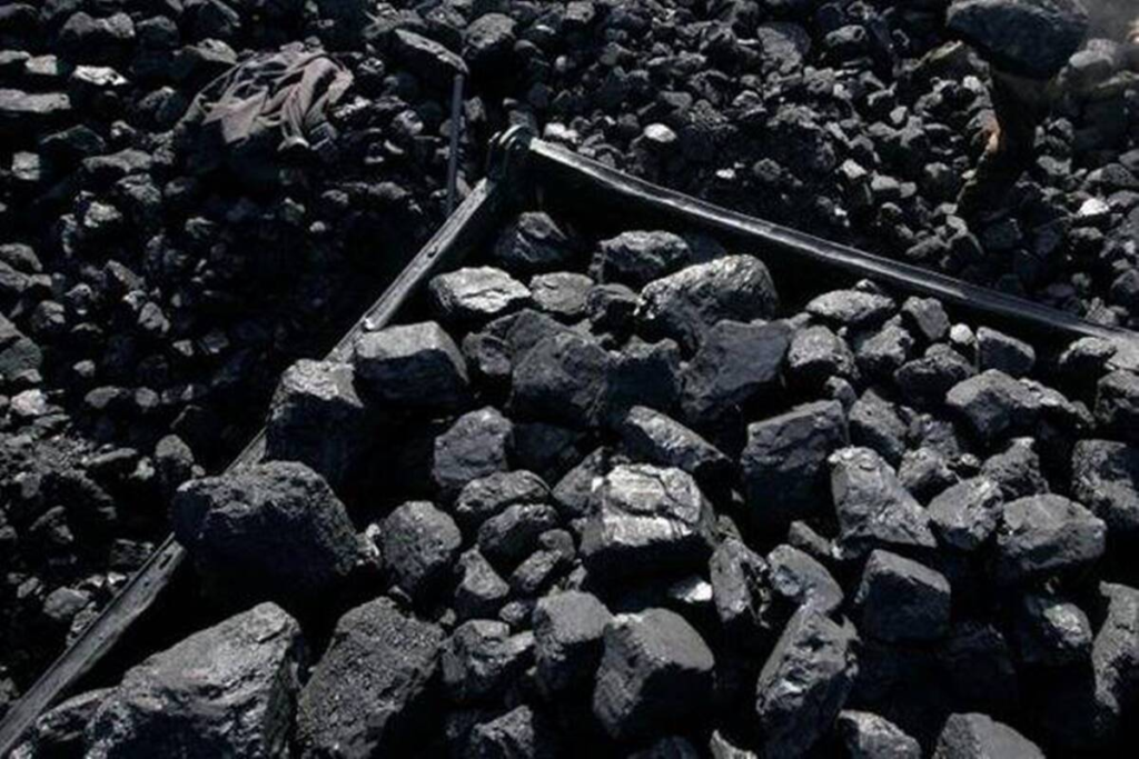
- Coal Reserves: Central India Coalfields, including Korba mines, produce a large share of India’s coal. Other important coalfields include Jhilimili, Sonhat, and Bisrampur.
- Iron Ore: Rowghat and Bailadila have major deposits, supporting the steel industry.
- Unique Mineral Resources: Only tin-producing state in India, along with limestone, dolomite, bauxite, and even diamond potential.
Information Technology Initiatives
- Chhattisgarh Infotech Promotion Society (CHiPS): Manages significant IT projects like Choice and Swan to support state infrastructure.
Exports
- Total Exports: US$353.3 million (2009–10), predominantly from Bhilai.
- Key Exports: Steel, handicrafts, blended yarn, food products, iron, aluminum, cement, and engineering products.
Here’s a streamlined summary with key points highlighted for easier review:
Human Development Indicators
- HDI: As of 2018, Chhattisgarh’s Human Development Index (HDI) stands at 0.613 (medium), ranking it 31st among Indian states.
- National Comparison: Below the national average of 0.647.
Standard of Living
- Urban vs. Rural Divide: Cities like Raipur, Durg, Bhilai, and Bilaspur offer medium to high standards of living. However, rural and forested areas often lack basic resources.
- Literacy Rates: Bhilai’s literacy rate is 86%, while rural Bastar has only 54% literacy.
Education
- Education Index: Higher than Bihar, Jharkhand, UP, and Rajasthan, with a score of 0.526.
- Urban Literacy: Urban literacy rate is 84.05% with male literacy at 90.58% and female literacy at 73.39%.
- Educational Support for Tribals: Programs like Ramakrishna Mission Asharama Narainpur work to uplift and educate tribal populations.
Health and Healthcare
- Health Index: Scored 52.02 out of 100 in NITI Aayog’s report, better than Madhya Pradesh, Haryana, Rajasthan, Odisha, Bihar, Assam, and Uttar Pradesh.
- Malnutrition and Child Mortality: High malnutrition rates, especially among tribal women, and Under Five Mortality Rate are higher than the national average.
Economic Growth
- Net State Domestic Product (NSDP): Chhattisgarh has an 8.2% NSDP growth rate (2002–2008), surpassing the all-India average of 7.1%.
- Per Capita NSDP Growth: Above the national average, yet income levels remain low compared to other states.
Urbanization
- Urban Population: 23.24% of residents live in urban areas, with 5.9 million people in cities like Raipur, Durg, and Bhilai.
Demographics
- Sex Ratio: Balanced at 991 females per 1,000 males; child sex ratio is 964 females per 1,000 males (Census 2011).
- Fertility Rate: Rural areas have a rate of 2.6 compared to 1.9 in urban zones; overall state rate is 2.4.
Scheduled Castes (SC) and Scheduled Tribes (ST) Population
- ST Population: Constitutes 30.62% of the state, one of the highest in India, largely inhabiting forested areas like Bastar.
- SC Population: 2.4 million as of the 2001 Census, around 12.8% of the total population.
Poverty Levels
- Poverty Ratio: Around 50% poverty rate in 2004–05, significantly above the national level. High poverty among rural STs and urban SCs, which impacts human development indicators.
Access to Drinking Water and Sanitation
- Drinking Water: About 91% have access to improved water sources, largely through tube wells/hand pumps.
- Sanitation: Low pre-Swachh Bharat with only 41% coverage; 90.31% rural sanitation achieved by 2017. The state won the 2020 cleanest state award for >100 urban local bodies and ranked 3rd in Swachh Survekshan 2023.
Infrastructure and Connectivity
- Teledensity: Increased to 68.08% in 2017 from below 10% in 2010.
- Road Density: National Highways density is 23.4 km per 1,000 km²; the Mukhyamantri Gram Sadak Yojana has built over 1,530 km of cement roads in villages as of 2016.
Witchcraft Beliefs and Social Reforms:
- Witchcraft Accusations: In some tribal communities, women are still accused of witchcraft (known locally as “tonhi”) for reasons like property disputes or personal vendettas. This has led to persecution, and accusations are sometimes instigated by village sorcerers, often paid to carry out such acts.
- Chhattisgarh Tonhi Atyachar (Niwaran) Act, 2005: This legislation aims to curb witch-hunting and protect women. However, enforcement challenges persist, necessitating judicial intervention to ensure women’s protection in these contexts.
Demographics:
- Population Trends: According to the Census of India, Chhattisgarh’s population growth rate has fluctuated significantly over the decades. For instance, the population saw a substantial 22.6% increase from 2001 to 2011, with 25.5 million people as of the last census.
- Ethnic Composition: Scheduled Tribes form about 30% of the population, and Scheduled Castes comprise 12%. Other Backward Classes (OBCs) account for 45.5%, with dominant castes like Teli, Satnami, and Yadav in plains areas, and tribes like Gond, Halba, and Kamar in forested regions.
Religious Distribution:
- Majority Religion: Hinduism is dominant, with 93.25% of the population, followed by Islam (2.02%) and Christianity (1.92%). Buddhism, Sikhism, and tribal religions are practiced by smaller groups.
- Notable Sects and Pilgrimages: The Satnamis, followers of Guru Ghasidas who opposed the caste system, represent a unique sect in Chhattisgarh. Important pilgrimage sites include the Bambleshwari and Danteshwari temples.
Language:
- Primary Languages: Chhattisgarhi is the primary language, spoken by 61.9% of residents, followed by Hindi (10.61%) and other tribal languages like Gondi, Halbi, and Odia. Chhattisgarhi is further divided into dialects such as Surgujia, which is distinct in the Surguja region.
- Multilingual Diversity: The language profile is rich, with indigenous languages like Kurukh, Korwa, and Gondi thriving in various regions. Migration has also introduced languages like Bengali, Marathi, and Telugu in certain border regions.
Gender Ratio and Social Status of Women:
- High Gender Ratio: Chhattisgarh’s gender ratio stands at 991 females per 1,000 males, making it one of India’s better-ranked states in this regard.
- Empowerment and Social Practices: Despite social challenges, rural women in Chhattisgarh are known to be relatively outspoken and organized. Traditions like “chudi pahanana” allow women the agency to end marriages, a rare custom in the Indian social landscape. The presence of goddess-centric temples reflects historical reverence for female divinity, though male dominance still exists in social structures.
Sources and Verification Needs:
- To strengthen the section on witchcraft and gender customs, verified sources, such as government reports or academic studies, could provide additional context and credibility, especially concerning the Tonhi Atyachar (Niwaran) Act and practices related to witchcraft accusations.
- Demographic and linguistic data from the latest census (or interim surveys) would provide updated insights, while anthropological studies on local customs could further validate observations on gender dynamics and cultural practices.
Chhattisgarh is known for its vibrant cultural heritage and diverse traditions, with significant historical and social influences visible in its art, dance, literature, and cuisine. Here’s an overview of the state’s rich cultural landscape:
Dance and Folk Traditions
- Panthi Dance: A folk dance of the Satnami community, performed to honor Guru Ghasidas on Maghi Purnima. The dancers display complex movements, often forming human pyramids.
- Pandavani: A narrative dance-drama based on the Mahabharata, led by a solo artist accompanied by musicians. Teejan Bai, a prominent performer, has popularized this traditional art form globally.
- Raut Nacha: Celebrated by the Yaduvanshi community, this dance is dedicated to Lord Krishna and performed during the post-Diwali festival.
- Suwa Nacha (Parrot Dance): This symbolic dance involves women dancing around a parrot in a bamboo pot, reflecting themes of devotion and unity.
- Karma Dance: Performed by the tribal communities, marking the transition from the rainy to the spring season, this dance symbolizes gratitude and is an integral part of the tribal lifestyle.

Literature and Crafts
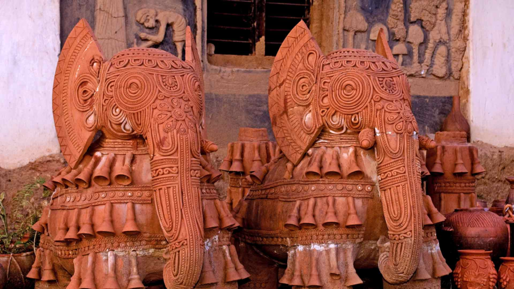
Chhattisgarh has a deep-rooted literary tradition that draws inspiration from mythology, daily life, and folklore. Local handicrafts like Kosa silk and Dhokra metalwork are widely appreciated for their intricate designs, used to make saris, salwar suits, and men’s attire. The state is also known for wood carving, bamboo ware, and tribal jewelry, all of which showcase the skill and creativity of Chhattisgarh’s artisans.
Theatre and Cinema
Theater in Chhattisgarh, known as Gammat, includes lyrical and dramatized forms like Pandavani. Films in the regional Chhattisgarhi language, collectively termed Chhollywood, celebrate local stories and music, contributing to the state’s entertainment industry. Legendary singers like Lata Mangeshkar and Mohammed Rafi have also lent their voices to Chhattisgarhi songs.

Cuisine
Known as the “Rice Bowl of India,” Chhattisgarh’s cuisine includes rice-based dishes and unique regional foods like Aamat, Bafauri, Dubkikadhi, and Muthia. The traditional Chhattisgarhi thali offers a variety of flavors, reflecting the state’s agricultural heritage and culinary creativity.

Festivals and Tourism
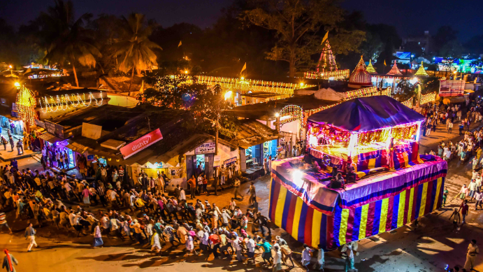
Chhattisgarh celebrates many festivals, from Bastar Dussehra to Rajim Kumbh Mela, drawing thousands of visitors and showcasing regional customs. The state’s tourism is enriched by natural and historical landmarks, including Buddhist sites, palaces, rock paintings, and wildlife sanctuaries. Highlights include Mainpat, known as “Mini Shimla,” and Maitri Bagh Zoo in Bhilai.
Sports and Recreation
Chhattisgarh hosts the Abujhmad Peace Marathon and the Chhattisgarhiya Olympics, a celebration of traditional Indian games like kabaddi and kho-kho. The inaugural event in 2022 attracted nearly 2.6 million participants, reflecting the state’s enthusiasm for sports and community activities.
Chhattisgarh has made significant strides in literacy over the past decade, reflecting improvements in access to education, especially for women. According to the 2011 Census:
- Overall Literacy Rate: 71.04%
- Male Literacy Rate: 81.45%
- Female Literacy Rate: 60.99%
Literacy Growth (2001 to 2011)
The decade saw an increase in overall literacy from 64.66% to 71.04%. Male literacy rose from 77.38% to 81.45%, while female literacy increased from 55.85% to 60.99%. This progress highlights efforts to reduce gender disparities in education, though female literacy still lags behind.
Educational Institutions
Chhattisgarh is home to several institutions of higher education, including universities, engineering colleges, and specialized institutes that contribute to academic development in the state.
Here’s a breakdown of the literacy data from the 2001 and 2011 censuses in Chhattisgarh:
| Description | 2001 Census | 2011 Census |
|---|---|---|
| Total Literates | 20,833,803 | 25,540,196 |
| Male Literates | 10,474,218 | 12,827,915 |
| Female Literates | 10,359,585 | 12,712,281 |
| Literacy Rate (%) | ||
| Overall | 64.66 | 71.04 |
| Male | 77.38 | 81.45 |
| Female | 55.85 | 60.99 |
Between 2001 and 2011, the total number of literates increased significantly, with male and female literacy rates both rising, though female literacy continues to trail behind male literacy. This improvement reflects focused efforts in expanding educational access and literacy programs across the state.

